


Part IV and Final Instalment of the MTD Investigates MH370 Series
The search for MH370 found shipwrecks.
It mapped mountains beneath the ocean.
It identified ravines, ridges and geological formations humans had never examined in such detail.
It found hundreds of sonar contacts worth investigating.
It found pieces of MH370 thousands of kilometres from where the aircraft is believed to have ended its flight.
It eliminated enormous areas of seabed.
What it did not find was the Boeing 777.
Twelve years after Malaysia Airlines Flight MH370 disappeared with 239 people aboard, that distinction matters.
Because describing the search as having “found nothing” fundamentally misunderstands what happened.
Every square kilometre examined to sufficient quality removed territory from the mystery.
Every recovered piece of debris provided another constraint.
Every satellite calculation narrowed the possibilities.
Every unsuccessful search changed the probability map.
And yet the central physical evidence remains missing.
The aircraft itself.
That leaves one final question for MTD Investigates:
How can the mathematics be broadly right, the searches professionally executed, and a Boeing 777 still remain missing?
The Search Began With an Extraordinary Disadvantage
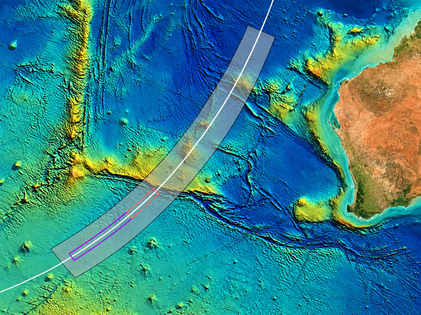
Most aircraft searches begin with a last known position relatively close to where the flight ended.
MH370 did not provide investigators with that luxury.
The final position established by conventional surveillance was near northern Sumatra.
The aircraft then continued for hours.
Its later journey had to be reconstructed from satellite communications metadata rather than conventional tracking.
As Part II established, those satellite exchanges did not provide GPS coordinates.
They provided constraints.
Possible distances from a satellite.
Possible directions.
Possible speeds.
Possible trajectories.
By combining those measurements with aircraft performance and fuel endurance, investigators developed a strong case that MH370 continued into the southern Indian Ocean.
But “southern Indian Ocean” is not a location.
It is an enormous body of water.
That difference turned the disappearance of one aircraft into one of the most difficult underwater searches ever attempted.
The Seventh Arc Was Never a Crash Site
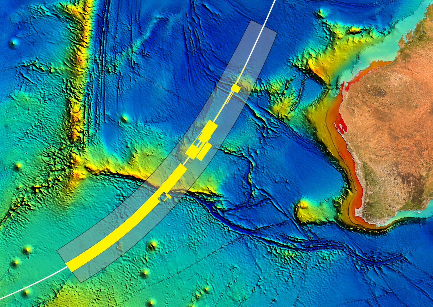
One line became central to everything that followed.
The seventh arc.
At approximately 00:19 UTC on 8 March 2014, MH370's satellite terminal initiated its final successful log-on sequence.
The timing measurement associated with that exchange constrained the aircraft to a vast arc of possible positions relative to the satellite.
That arc became the principal geographical reference for the end of the flight.
But it was never a crash coordinate.
It did not tell investigators:
MH370 is here.
It told them something closer to:
At this moment, MH370 was probably somewhere along this enormous line.
Investigators then faced another problem.
Even if the aircraft was close to the seventh arc during its final satellite exchange, how far could it have travelled afterwards?
That depended on what happened during the final minutes.
Was anyone still controlling it?
Was it on autopilot?
Had fuel exhaustion begun?
Did it enter a steep uncontrolled descent?
Did somebody attempt a glide or ditching?
Different answers moved the possible wreckage field.
And underwater, a small difference in the final minutes could become kilometres of additional seabed.
How Wide Do You Search?
Search planners therefore faced uncertainty both along the seventh arc and away from it.
The final satellite frequency data were consistent with a substantial descent around the last exchange.
Investigators modelled end-of-flight scenarios.
They examined aircraft behaviour around fuel exhaustion.
Recovered debris was studied for possible clues about configuration at impact.
By the 2016 First Principles Review, analysis increasingly supported an end point relatively close to the seventh arc.
Experts identified a new approximately 25,000-square-kilometre priority area between roughly 33°S and 36°S and assessed that the aircraft was likely within approximately 25 nautical miles of the arc.
That sounds precise.
In an underwater search, it is not.
Twenty-five nautical miles around a long arc still means an enormous amount of seabed.
And that seabed is anything but flat.
A Landscape Built to Hide an Aircraft
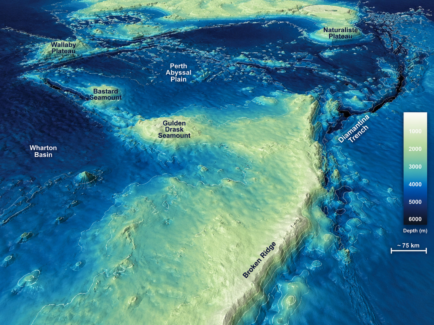
Thousands of metres below the southern Indian Ocean are underwater mountains.
Ridges.
Steep slopes.
Deep depressions.
Sediment.
Broken terrain.
Sonar does not simply photograph the bottom like a camera passing over a floor.
Search vessels and autonomous underwater vehicles build acoustic images of complex terrain.
Those images must then be processed and interpreted.
Contacts have to be classified.
Promising objects may require another pass from another direction or with another sensor.
During the original search, hundreds of sonar contacts were investigated.
Some were geological.
Some were man-made.
Several were shipwrecks.
None was MH370.
The search therefore did not find nothing.
It created an enormous negative map.
Sonar could not tell investigators where MH370 was. Kilometre by kilometre, it told them where it probably was not.
More Than 120,000 Square Kilometres — And Still Nothing
The scale of the original underwater operation is difficult to comprehend.
Hundreds of thousands of square kilometres were mapped to understand the seabed terrain.
More than 120,000 square kilometres were then subjected to detailed underwater searching.
The priority zone had been derived from satellite analysis, aircraft performance and assumptions about the end of the flight.
By January 2017, that phase of the search was suspended.
MH370 had not been found.
That did not necessarily mean the southern Indian Ocean hypothesis had failed.
It meant something more specific:
the aircraft was not located where the combination of evidence and modelling had assigned the greatest probability.
And that new information mattered.
The failure of one search does not necessarily destroy the model. It changes the probability map.
Then the Ocean Returned Pieces of MH370
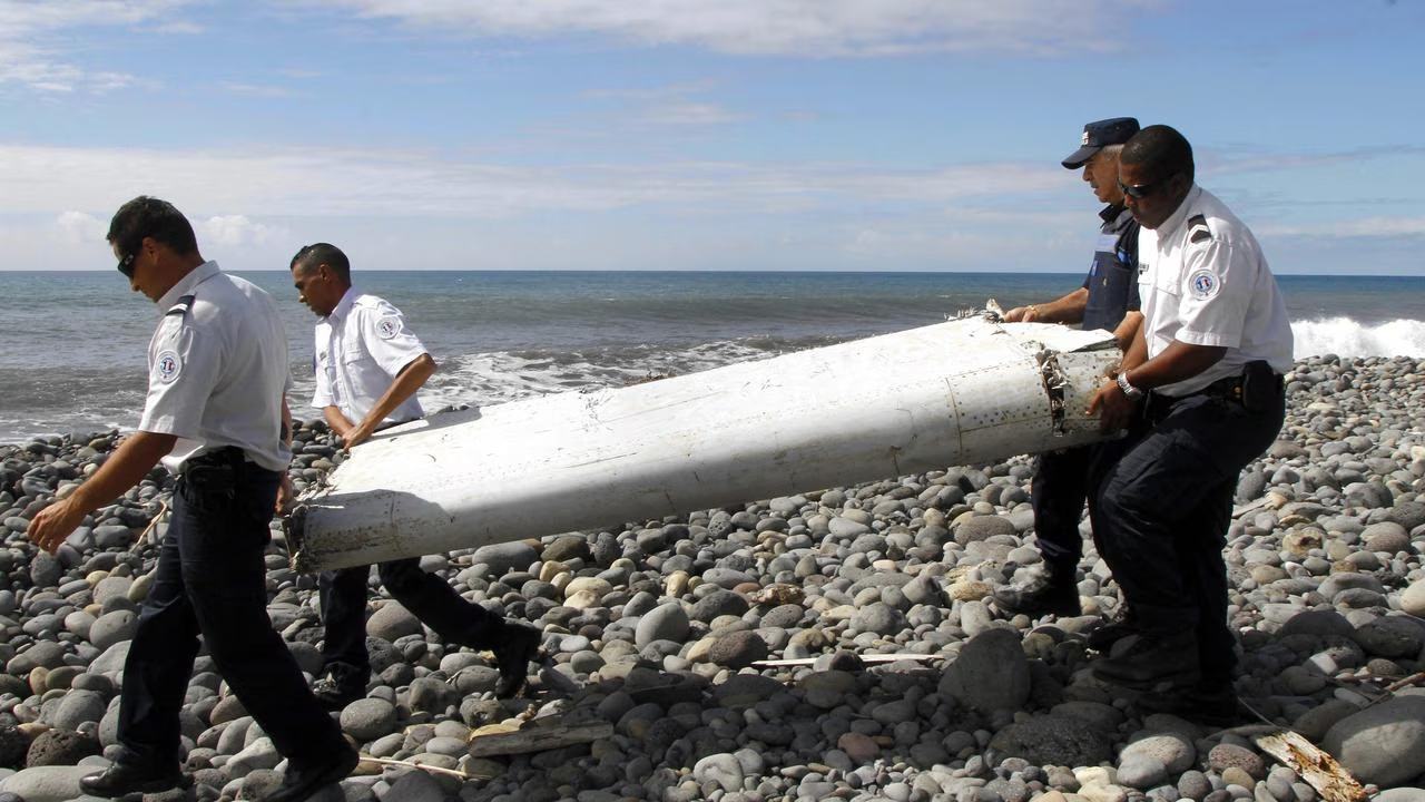
The main wreckage remained hidden.
Pieces of it did not.
In July 2015, a flaperon washed ashore on Réunion Island in the western Indian Ocean and was identified as coming from MH370.
Other debris subsequently appeared along western Indian Ocean shores and the east African coastline.
Some pieces were confirmed or assessed with varying degrees of confidence as originating from the missing aircraft.
The significance was enormous.
Physical evidence now supported something satellite mathematics had already indicated:
MH370 had reached the Indian Ocean.
But floating wreckage does not remain where an aircraft crashes.
Currents move it.
Wind affects it.
Waves affect it.
Different shapes behave differently in water.
A component found thousands of kilometres away cannot simply be traced backwards along a straight line.
So investigators attempted something far more difficult.
They tried to run the ocean backwards.
Running the Ocean Backwards
Oceanographers modelled currents across the Indian Ocean.
They released virtual debris.
They compared predicted landfalls with actual discoveries.
They studied the effects of wind and waves.
Researchers even tested the drifting behaviour of a Boeing 777 flaperon to better understand how such a component would move through water.
The modelling strengthened the case for an origin in the southern Indian Ocean and helped refine areas along the seventh arc.
Some analyses particularly supported regions around approximately 35°S.
But drift modelling could not produce an exact crash coordinate.
The ocean is not a conveyor belt.
It is turbulent.
Small differences at the beginning of a drift can become enormous differences after months of currents, storms and changing winds.
The debris therefore accomplished something important without solving the case.
It independently strengthened the case for the ocean. It did not identify the square kilometre.
Ocean Infinity Tried Again
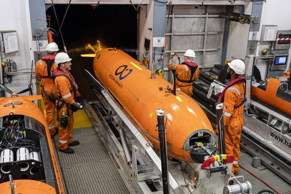
In 2018, Ocean Infinity launched another search using autonomous underwater vehicles capable of surveying large areas of seabed.
More than 100,000 additional square kilometres were examined.
Again, MH370 was not found.
By then, the combined searches had examined close to 200,000 square kilometres.
That sounds devastating to the southern Indian Ocean reconstruction.
But scale works both ways.
Searchers were looking for a debris field several kilometres underwater in a region derived from probabilities after the aircraft had gone hours without conventional position tracking.
The achievement was enormous.
So was the remaining uncertainty.
And underwater search coverage is not magical certainty.
Terrain creates acoustic shadows.
Sensor performance varies.
Small gaps can remain.
Old sonar data can later be revisited when a new hypothesis identifies a particular location.
That has happened in the MH370 investigation.
Additional contacts in previously collected data have been re-examined.
None produced a credible MH370 debris field.
That increased confidence in the original searches.
But it also demonstrated an important principle:
“Searched” describes the quality of evidence against a location. It does not mean omniscience.
The Air France Lesson
Air France Flight 447 provides useful perspective.
It disappeared over the Atlantic in 2009.
Investigators had major advantages compared with the MH370 search.
The approximate crash region was much better constrained.
Automated fault messages had been transmitted.
Floating wreckage was found within days.
Bodies were recovered.
Yet the main wreckage and flight recorders remained on the seabed for almost two years.
Multiple searches failed before the aircraft was located.
AF447 and MH370 were fundamentally different events, and the comparison should not be stretched beyond its purpose.
But it demonstrates one important principle:
Failure to find an aircraft where experts expect it does not automatically mean the broad location is wrong.
MH370 began with far greater positional uncertainty.
That disadvantage has followed every search vessel into the Indian Ocean.
The Search Returns

More than a decade after MH370 disappeared, Malaysia authorised another attempt.
A new no-find, no-fee agreement with Ocean Infinity targeted approximately 15,000 square kilometres of the southern Indian Ocean considered sufficiently promising to justify another search.
Operations took place during 2025 and early 2026.
Across 28 operational search days, approximately 7,571 square kilometres were examined.
MH370 was not located.
But that sentence requires an immediate qualification.
The newest search area has not been completely searched.
Roughly half remained outstanding after the 2025/26 operational phases.
In June 2026, the agreement was extended for another year, allowing the effort to continue toward June 2027.
As this final part of MTD Investigates is published, the newest chapter of the MH370 search is therefore unfinished.
It would be incorrect to say the latest operation proved MH370 was not in the newly designated area.
Thousands of square kilometres remain to be examined.
The ocean has not yet delivered its verdict.
What If They Search the Rest — And Still Find Nothing?
Suppose the remaining area is eventually searched to high confidence.
Suppose MH370 still is not found.
That would be important.
But it would not automatically mean Inmarsat was wrong.
The satellite data constrain the aircraft's position at specific times.
They do not provide a continuous recorded flight path.
Part II established the distinction:
The arcs were measurements. The routes connecting them were model-derived candidate paths.
Another unsuccessful search would therefore force investigators back toward the assumptions connecting those measurements.
Speed.
Heading.
Altitude.
Turns between handshakes.
Fuel performance.
End-of-flight dynamics.
Distance travelled after the final satellite exchange.
None needs to be dramatically wrong.
That is the cruel geometry of MH370:
A small uncertainty in the air can become an enormous uncertainty on the seabed.
How Far From the Seventh Arc?
The final BFO values were consistent with a rapid descent around the last satellite exchange.
That weighs against an aircraft continuing for a very long distance in stable flight after the seventh arc.
End-of-flight simulations similarly concentrated probability relatively close to the arc.
That is why search planners progressively focused on corridors around it rather than treating the entire southern Indian Ocean as equally plausible.
But probability is not observation.
Without the flight data recorder, investigators do not know the exact control inputs.
Without the wreckage, they cannot reconstruct the final aerodynamic state.
Without the cockpit voice recorder, they do not know whether anyone remained conscious and in control.
A controlled glide could move the impact point.
An uncontrolled descent could keep it much closer.
The seventh arc remains the strongest geographical anchor.
It is not a wall beyond which MH370 cannot exist.
What Finding MH370 Could Actually Solve
Finding the aircraft would immediately answer the most basic remaining question.
Where did the flight end?
But its importance goes much further.
Wreckage distribution could provide evidence about impact attitude and energy.
Control surfaces could help establish aircraft configuration.
Structural damage could potentially distinguish aspects of a high-energy impact from a more controlled contact with the ocean.
Aircraft systems might preserve physical clues.
And then there are the recorders.
The flight data recorder could transform our understanding of the final flight.
The cockpit voice recorder could be even more consequential.
But expectations need restraint.
The cockpit recorder installed on MH370 retained only a limited rolling period.
If the decisive events occurred many hours before impact and recording continued normally afterwards, those early cockpit conversations may have been overwritten.
After more than twelve years underwater, recovery and readability would also present technical challenges.
Finding MH370 therefore does not guarantee that every question will suddenly have an answer.
But it would do something this case desperately needs.
It would replace some inference with physical evidence.
What Four Parts Have Established
Across this series, MTD Investigates has deliberately resisted turning uncertainty into certainty.
Part I reconstructed MH370's disappearance from normal air-traffic surveillance and found the sequence substantially more consistent with deliberate human intervention than with a conventional systems failure.
Part II examined the satellite evidence and concluded that the southern Indian Ocean is strongly supported, while the precise route and impact location were reconstructed rather than directly observed.
Part III tested the principal explanations and concluded that the publicly available evidence supports deliberate and technically competent human intervention more strongly than it identifies the person responsible.
Part IV brings those findings together.
MH370 is neither completely unknowable nor solved.
There is a substantial evidence chain:
radar;
satellite communications;
aircraft performance;
fuel modelling;
debris;
ocean currents;
sonar.
Each answers a different question.
None answers all of them.
MTD's Final Assessment
The failure to find MH370 does not, by itself, overturn the southern Indian Ocean reconstruction.
Too many independent lines of evidence point broadly in that direction.
But twelve years of searching expose the remaining weakness.
Precision.
Satellite evidence narrowed the world to an ocean.
Flight modelling narrowed the ocean to arcs and corridors.
Drift modelling refined the probabilities.
Sonar eliminated enormous areas of seabed.
Yet none produced the one thing investigators ultimately need:
a physical location.
MTD therefore reaches a final conclusion:
The mystery of MH370 may no longer be primarily about which ocean the aircraft entered. It may be about how small uncertainties in its final hours became enormous uncertainties on the seabed.
Every unsuccessful high-quality search narrows the remaining possibilities.
It does not necessarily make them simpler.
And the newest search is not finished.
Thousands of square kilometres remain.
There is still ocean left on the map.
There is still evidence left to find.
239 People

For investigators, MH370 is a problem of radar tracks, satellite arcs, Doppler shifts, ocean currents and sonar returns.
For the families of 239 people, it has never been an equation.
They lost parents.
Children.
Husbands and wives.
Brothers and sisters.
Friends and colleagues.
They have lived through more than twelve years of announcements, searches, theories, discoveries, disappointments and renewed promises.
No mathematical model can resolve that loss.
No probability map can provide closure.
And no investigation should allow fascination with the mystery to eclipse the people at its centre.
Radar told us MH370 turned back.
Satellites told us it flew on.
Debris told us it reached the Indian Ocean.
Sonar has told us where it probably is not.
What none of them can yet tell 239 families is where the aircraft lies — or exactly what happened aboard it.
Somewhere beneath the southern Indian Ocean may still lie the physical evidence capable of connecting those fragments into an answer.
Until it is found, uncertainty belongs to the investigation.
The loss belongs to the families.
MTD Investigates dedicates this series to the 239 people aboard MH370 and to the families who have waited since 8 March 2014 for answers.
This Concludes MTD Investigates: MH370
Our four-part investigation ends here.
The search does not.
If the aircraft is located or significant new primary evidence emerges, MTD Investigates will return to the case.
Until then, the most responsible conclusion is also the simplest:
We know far more about MH370 than we did on the morning it disappeared.
We still do not know enough to tell 239 families exactly what happened.
Sources & Methodology
MTD Investigates based Part IV primarily on official technical and investigative material produced by the Malaysian MH370 Safety Investigation Team, the Australian Transport Safety Bureau, Australia's Defence Science and Technology Group, CSIRO and official information concerning the renewed Ocean Infinity search.
The original ATSB-led underwater operation mapped hundreds of thousands of square kilometres of seabed and conducted detailed sonar searching across more than 120,000 square kilometres. Contacts identified during that operation were assessed and, where warranted, subjected to further investigation. The operation did not locate MH370.
The 2016 First Principles Review reassessed satellite data, end-of-flight modelling, aircraft performance, debris evidence and previous search coverage. It identified an additional approximately 25,000-square-kilometre priority area between roughly 33°S and 36°S and assessed the aircraft as likely to have ended relatively close to the seventh arc.
Recovered debris, including the flaperon discovered on Réunion, provided physical support for an Indian Ocean impact. Subsequent drift modelling used ocean circulation, winds, waves and the measured behaviour of Boeing 777 debris to refine geographical probabilities. These models constrain likely origin regions but do not provide a unique impact coordinate.
Ocean Infinity's 2018 operation expanded underwater coverage substantially. Combined with the earlier search, close to 200,000 square kilometres of seabed had been examined without locating the main wreckage.
A renewed Ocean Infinity operation under agreement with Malaysia targeted approximately 15,000 square kilometres. During operational phases in 2025 and early 2026, approximately 7,571 square kilometres were searched over 28 operational days without locating MH370. The agreement was subsequently extended into 2027, leaving a substantial portion of the designated area still to be examined at the time of publication.
MTD distinguishes throughout between:
direct observations;
official investigative findings;
model-derived probability;
areas eliminated through underwater search;
and MTD analysis.
A failed search is not treated as proof that the broader southern Indian Ocean reconstruction is incorrect.
Nor is a modelled high-probability area treated as proof that the aircraft must lie within it.
The final distinction is the same one that has guided this four-part investigation:
Evidence can narrow a mystery without solving it.
And until MH370 is physically located, the most consequential evidence remains somewhere beneath the ocean.